Temporary Road Closure – (Sandy & Moggerhanger: National Cycle Route No 51)
Date Added: 01/11/2022
Please see below, Central Bedfordshire Councils proposed request for a temporary road closure for Sandy & Moggerhanger.
PUBLIC NOTICE
ROAD TRAFFIC REGULATION ACT 1984 - SECTION 14(1)
CENTRAL BEDFORDSHIRE COUNCIL
(NATIONAL CYCLE ROUTE NO 51, SANDY AND MOGGERHANGER)
(TEMPORARY PROHIBITION OF THROUGH TRAFFIC) ORDER 2022
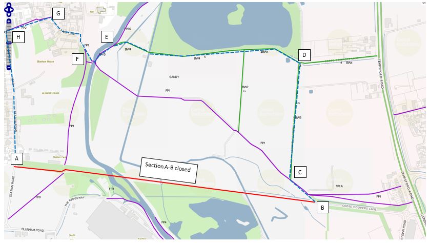
Notice is hereby given that Central Bedfordshire Council have made an Order the effect of which will be to prohibit any person proceeding on foot or on cycle along the length of National Cycle Route No 51, Sandy and Moggerhanger which extends from Ordnance Survey Grid Reference (OS GR) TL 1610 5039 (map point B) to OS GR TL 1499 5053 (map point A).
This temporary closure is required to enable surface improvement works. The closure is expected to take place from 7th November to 14th November.
The alternative route for National Cycle Route users while the closure is in operation will be:
From OS GR TL 1610 5039 (map point B), head north westerly along Footpath No 1 to Bridleway No 3 at OS GR TL 1601 5048 (map point C), continue northerly along Bridleway No 3 to Bridleway No 4 at OS GR TL 1604 5090 (map point D), then head in a generally westerly direction along Bridleway No 4 to Footpath No 10 OS GR TL 1534 5096 (map point E). Continue south easterly along Footpath No 10 to Footpath No 1 and across the river to OS GR TL 1527 5091 (map point F), then head north westerly on Footpath No 1 to join Park Lane. Continue along Park Lane in a north westerly direction to the junction with Footpath No 2 at OS GR TL 1512 5107 (map point G) and then head west south westerly along Footpath No 2 to Station Road OS GR TL 1495 5102 (map point H), finally head in a southerly direction along Station Road to OS GR TL 1499 5053 (map point A) and vice versa.
Please note that points B-C, E-Park Lane and G-H are footpath only and cyclists must dismount.
Further details, including a map, can also be found on the Council’s website at: https://www.centralbedfordshire.gov.uk/info/82/countryside/431/rights_of_way/2
The Order will come into operation on 7 November 2022 for a period not exceeding six months or until the works which it is proposed to carry out on or near to the National Cycle Route have been completed, whichever is the earlier. If the works are not completed within six months the Order may be extended for a longer period with the consent of the Secretary of State for Transport.
For further information please contact - Chris Dorow, Tel: 0300 300 6906.
Email [email protected]
DATED 4 November 2022
Jill Dickinson
Deputy Director
Place & Communities
Central Bedfordshire Council
Priory House
Chicksands
Shefford
SG17 5TQ